Worrall Travel R's

Worrall Travel R's
Roz and Russ

Worrall Travel R's - Kicking the Bucket List

Tuesday, February 15, 2011

Dunedin to Invercargill

From Top to Bottom

As of today, Tuesday, February 15, we have traveled from the Top of the North Island, Cape Reinga, to Slope Point, southeast of Invercargill, a linear distance of approximately 1,400 kilometers.  The actually distance is more than that as we have zigged and zagged across the country from east coast to west coast and back during the last two and half months.    Tomorrow will begin our northbound journey up the west coast of the South Island,

But let’s back track a bit.

Dunedin

We arrived in Dunedin from Moeraki on Wednesday, February 9 in the early afternoon.  Luckily we arrived early. There were only three powered campsites available.  A large caravan group from England was expected later in the day.

We spent the afternoon driving around the city, taking photographs of the old Victorian buildings, many reminiscent of those we saw in Scotland.  The first permanent European settlers were from Scotland.  Late in the afternoon, we drove out to the headlands area where the Northern Royal Albatross are known to nest.  They are such huge, heavy birds they nest on high headlands and run off the cliffs into the thermals to take off.

They spend over 80 percent of their life over the water and only come ashore to lay their eggs and to raise their young.  Baby albatross do not reach maturity and start to fly until they are nearly a year old.  We were able to see several of these gigantic birds flying in from the sea late in the afternoon. 

Unfortunately, I lost of the photographs of our first day of Dunedin when Mac crashed.  Fortunately, all the other photos had been backed up. Here is a museum shot of an albatross.

On our second day in Dunedin, we visited the Cadbury Chocolate Factory.  They have some cute exhibits, but don't allow photographs inside the factory.


The best part of the visit was getting to eat the chocolates.  We’ve since been on a serious carb high as we sample all of the goodies.  New Zealand is a huge dairy producer which is a good thing as the Cadbury factory uses 200,000 liters of milk a day to produce its milk chocolates.

On the third day, we spent most of the day at the Otago Museum.  We are becoming so familiar now with New Zealand history, culture, flora, and fauna that there were parts of the museum we could breeze through.  Still there is much to learn and there were some fascinating exhibits including an explanation of the Moeraki Boulders, mudstone concretions.  One of the fascinating exhibits in the museum was all about faces and facial expressions.   We had some opportunities to put our faces in to some famous artwork.
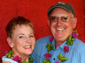
Saturday, Russ and I got up early and went into Dunedin to take the train to the Taieri Gorge. The Saturday morning farmers’ market was in full swing at one end of the rail yard.


The trip was a half day trip and back from the magnificent Edwardian railway station at sea level to Pukerangi at 250 meters above sea level.  The vintage train hugged cliffs, chugged through long dark tunnels, and crossed over several viaducts through picturesque gorges.


 Built in the late 1800’s and open for business in 1889.  After 100 years of service transporting agricultural goods and building materials for the Clyde Dam, the railroad was closed down.  The city of Dunedin purchased the train and track for tourist excursions, and it is one of Dunedin’s leading tourist attractions toda

Barbara and Bruce
We had a fair weather day and enjoyed the ride and the company of an Auckland couple who sat across from us on the train.They are headed for India, and we hope to catch up with their travels in April when we are back in Auckland.

OH NO!
Upon returning to Dunedin, Russ and I headed south and hour and half out of the city to a little place called Kaka point where we camped for the night.  When we reached the campsite, Russ wanted to do some tax work and discovered that he had left his paperwork binder (lots of information, credit cards, etc.) in the kitchen at the Dunedin campground.  Yipes!  Not good!

After a few frantic minutes, we were able to contact the campground, and yes they had our binder.  One of our fellow campers had found it and tried to bring it to us but we had already left for the early morning train trip.  He turned it in to the office and the office sent us an email. We were so thankful.  We got up early the following morning and returned to Dunedin to retrieve the binder.  With the binder in hand, we headed south once again to Owaka and Pounawea.

Owaka
We visited the Owaka museum and fell in love with a small New Zealand quilted wall hanging, created by NZ Quilting Artist Corale Hollocks, which will be our primary souvenir of New Zealand.

Not far from our campground in Pounawea, we drove to a trail head and hiked to a Jack’s Blowhole.  The blowhole is 200 meters from the ocean and is similar to the sink/blow hole up in the Mendocino headlands.  The sea surges in through a cavernous opening into this big pit and the waves crash around.  It is an interesting and beautiful geological feature.


Michael and Karen

It was a cold and windy walk to the blowhole.  I wore my Alaskan fleece headband with “Alaska” embroidered across the front. We met another couple at the blow hole…..from Palmor,Alaska.  We’ve gotten so used to Kiwi, British, and German accents, it was a treat to talk with some other Americans.  Both school teachers, this couple just retired and are in NZ for two months.

We only stayed one night at Pounawea, and the following morning continued our southerly drive down the coast.  It was a magnificently clear day.  .Our first mini hike of the day was to the Purakanui Falls.   


Once again in the car, we rounded the bend at Papatowi we looked down on the magnificent beach of  Tautuku Bay.  It was sweeping crescent shaped bay with long graceful waves breaking on the sand.  We stayed in a campground close to the McLean waterfall. 


The McLean Falls Motel and Holiday park was in Chaslands.  It was definitely one of the nicer campgrounds we have stayed in.  They had a lovely cafĂ© that served up Mexican food along with gluten-free fudge brownies.  While staying at the camground, we took a nice walk to the McLean Falls and enjoyed the colorful mushrooms on the side of the road. 

Later in the day when the tide was low, we trekked  down through a fern forest and across a golden sand beach to the Cathedral caves .


The cave has two entrances.  When the tide is low, we could walk through one entrance and exit around the corner to the other.  It can be a very dangerous place when the tide is high and the trail head down to the beach is gated off until just one hour before low tide and one hour after low tide.

Southern Tip, Slopes Point & Bluff
Tuesday, February 15 is the day we reached the southern most point, Slopes Point, of the south island.  To commemorate, we pulled out all of our geocaching travel bugs and took their pictures with the GPS.


Travel Bugs from Left to Right:   Hang a Left (Hal) Pirate, Cruising 1, Gordon the Gnome, and Dragon of the West


 Slopes point is a windswept headland where the grass grows sideways and the ground cover hugs on to the soil with all of its might.

 Later in the day, we also drove to Bluff which technically is not the farthest south point, but is traditionally considered the southern most point as the scenic highway ended here.

Invercargill

We are in Invercargill this evening.  I was able to get my haircut this afternoon.  We did some sightseeing of local buildings, and did a little grocery shopping.  Our Internet connection isn’t great here at the campground, so we will look for a better connection in the morning.  We would like to find at least one geocache in the area before leaving so that we can log the travel bugs in and give them mileage credit.  Oh what we do for the love of a geocaching adventure!

There is a high pressure system over the southwest coast now, so we made arrangements to take an all day boat tour through Doubtful Sound on Thursday.

Still having fun.  All is well with the 2 Sail R's

Wednesday, February 09, 2011

NZ South Island, Akaroa to Moeraki via Mt. Cook


Fairlie

On this leg of our New Zealand excursion, we traveled from the east coast of the South Island and the little French flavored town of Akaroa southwest to Fairlie, Lake Tekapo, Mount John, Mt. Cook, and back to the east coast to the little fishing village of Moeraki.

The town of Fairlie is in the heart of the Mackenzie valley. 


It’s most famous or infamous citizen and founder, James Mackenzie, according to the historical monument acquired in the middle of the night 1,000 sheep from a region nearby to start his own sheep ranch.  Today Fairlie is a quiet little town.  We stayed three days in Fairlie walking along the stream, playing 18 holes of golf, and meeting the local folks.

On one of our walks we met Collin McKinnon, a Fairlie gentleman, pruning the trees in front of the Mackenzie Highland Pipe Band building.  Collin invited us to the band practice the following evening.  We returned to the practice the following evening and enjoyed the bellowing and piping of the band.  Most of the pipers were women.  Being inside during the practice was quite and experience.  I thought our eardrums would pop it was so loud.  The pipes were much more enjoyable outside and the pipers were very gracious in letting us visit them during their practice and their march down the road to a fellow piper’s home.  We especially enjoyed a duet by Collin (below) and fellow piper Ivan after the formal practice.

Front Row: John, Ivan, and Collin
The band leader was John Campbell.  Russ’s great grandfather was named John Campbell, so it was fun to talk with this man who might be a very distant relative and whose ancestors immigrated from Scotland to New Zealand in the mid 1800’s.

The following morning as we were getting ready to leave, Collin stopped by the campground with a bag of fresh vegetables from his garden – carrots, cabbage, cauliflower, and new potatoes.  What a delightful treat.  We stopped at the grocery store on our way out of Fairlie and bought some corned beef so that we could enjoy these vegetables properly.

Lake Tekapo and Mount John
We arrived in Lake Tekapo in the late afternoon.  It was spitting rain off and on.  The lake is glacial melt and has an interesting milky blue-green appearance.  We took a walk in the late afternoon and spent the early evening sitting in some lovely hot pools near the campground.


The following morning, we awoke to a gorgeous day.  We drove to the top of Mount John, just above Lake Tekapo and enjoyed carrot cake and coffee as we enjoyed the fabulous views, including our first glimpse of Mt. Cook in the distance.
Mount John Observatory


Orange juice, cappucino, carrot cake, and view.  What more could you want?

After our spectacular breakfast, we continued toward Mt. Cook. 


Mt. Cook
Our campsite had a fabulous view of Mt. Cook.  We knew that the weather was going to close in on us, so we took two walks the first afternoon to:

Mueller Glacier and Lake


and the second walk to the bottom of the  
Tasman Glacier and Lake Tasman where icebergs were floating in the water.


From our campsite, the sunset on Mt. Cook  was gorgeous.

Hooker Glacier and Hooker Lake Hike
The following morning, a high cloud cover was beginning to form and the forecast was for rain by late afternoon.  We got an early start for our walk up to the Hooker Glacier and Hooker Lake.  The walk was lovely and included quite a bit of rock hopping up an active stream bed. 


We tramped across the two swing bridges over the rushing glacial waters with gusting winds… chilling and thrilling.  We were glad to get across and put our feet on solid ground.


Clouds enveloping the mountain

By late afternoon, we had returned to our campsite.  We could not even see the mountain.  It started to rain during the night and continued for 24 hours.  We spent our last day on Aoraki/Mt. Cook in the Sir Edmund Hillary Alpine Center.  There is a wonderful theater and planetarium.  So while the mountain was shrouded with clouds and rain, we were indoors enjoying five presentations including a 3D movie of Mt. Cook, the biography of Sir Edmund Hillary, and 3 planetarium shows including one on black holes which was fascinating.

We left Mt. Cook around 4:00 in the afternoon and drove southeast for a couple of hours until we were back in sunshine.  We spent the night in a little campground in Omarama.  The river water was milky blue green just like the lakes and apparently the trout fishing was excellent.  It seemed odd to us that the trout fishing would be so good in the milky waters.  The fisherman certainly couldn’t see the trout hiding in the shadows, and it was surprising that the trout could even see the bait.

Omarama
When we arrived in Omarama in the late afternoon, it was 90 degrees, unseasonably warm.  By midnight, it was pouring rain and cold.  We left the following morning in the rain and continued on our way to the east coast, stopping several times to look at Maori cave art in limestone rocks and formations.


Does this look like a serpent head to you?


Oamaru
One of our stops was in the east coast city of Oamaru.  It is an old port city with distinctive Victorian era architecture in the original section of town.  Sandstone sculpture is one of the primary art forms here.  Some of the buildings are made of limestone which are slow deteriorating. 


Moeraki
We arrived in Moeraki Monday night February 7. 


 It rained again and we spent much of the late afternoon and evening in the communal kitchen chatting with other tourists from around the world.  The following morning we lounged about until late morning then hiked up the beach during low tide to the Moeraki Boulders.


Look!  It's a baby dinosaur.


These ancient egg shaped rocks are believed to have rolled around the ocean floors and deposited as the oceans receded.  Farmers often dig them up in their nearby fields.  When they crack open, they look like giant dinosaur eggs.  Some of them have very interesting patterns inside and out.

Late in the afternoon of the same day, we drove out on the Moeraki peninsula to the lighthouse and penguin reserve.  We had heard the best time to observe the rare yellow eyed penguin was late in the afternoon before dusk when they return from fishing in the sea.  It was quite cold and windy on the peninsula, but it was well worth the effort.   We were rewarded with several seal and penguin sightings and lovely scenery.


Still chick fuzz on the neck

My Mac is acting up and I think is dying.  I may not be able to post anymore photos for a while.  Fortunately, I had uploaded these photos to Picasa before Mac croaked.  We'll see what happens, but these may be the last photos for a while.  Other than that......


All is well with the 2 Sail R’s, Travel R’s, Camp R’s